- Using Google Maps Directions Feature - Slide 1The first step in using and form of intracity transportation (car, bus, subway, tram or train) is to ascertain the most favorable mode of transportation and the route. The best way to do this is with Google Maps. After opening the application, beginning typing the name or address of your destination.

- Find the Directions to your Destination - Slide 2After locating the Google Maps marker for Big Ben through the search option click the Directions icon.

- Use your current location as the Departure Point - Slide 3Choose your departure point by clicking inside the top search field. If your currently at the Departure Point (in our example, at the Tower of London) you merely click the Your Location. (You must have GPS location tracking turned on your mobile device.)

- Search for a Departure Location - Slide 4If you are wanting to select a Departure Location other than your current location, begin typing the name or address of your desired Departure Location (e.g. begin typing “Tower of London”) to ascertain the directions from that location. Google Maps will present you with several options below the field in response to your typed words. Select the best option for your Departure Location for the desired route search.

- Select the mode of transportion - Slide 5By default Google Maps will display the modes of transportation (e.g. car, public transport, walking, etc.) from your previous search. In our example the search produced the best routes for transportation by car. To see the public transportation options (e.g. bus, tram, subway, train or boat) click the public transportation icon along the top of the search box.

- Selecting a Date and Time of Departure - Slide 6By default Google Maps will show you the recommended routes based on an immediate time of departure.

- The Departure Time Drop-down Menu - Slide 7You can, however, search for the best routes leaving or arriving at a specific time, either on the current date or a future selected date.

- Date and Time of Departure - Slide 8In our example we’ve chosen to see the routes with a departure date and time of Sunday, July 24th at 10:00 a.m. (Traveling outside of the USA Google Maps will show military time by default. So for a departure time at 3:00 p.m. you would select 15:00 from the drop-down menu.)

- Recommended Routes - Slide 9Google Maps will provide a list of four routes for the mode for transportation you’ve selected with the most favorable at the top based Google’s algorithm. The recommended route in our example is the route taking the District (Green) Metro Line.

- Route Summary - Slide 10The summary of the route indicates that it will take 17 minutes and requires about 8 minutes in total of walking. This includes the walk to the departure station, walking for transfers between stations, and walking from the final station to the destination location. The summary also indicates that the subway is expected to depart from the Tower Hill Station at about 10:07 a.m.

- See the Route Details and Timeline - Slide 11This looks like the best option. Click on the “Details” link to see the route details and timeline.

- Share the Route - Slide 12We can now see the details of the route. Google estimates it will take 7 minutes to walk the 1/10ths of a mile from the Tower of London to the Tower Hill station. We will take the District Line in the direction of Richmond at Platform 1 of the Tower Hill station. The subway trip will take an estimated 9 minutes and includes 7 stops. We directed to exit the subway car at the Westminster station. Big Ben should be about 400 feet away if we exit in the direction of the landmark. We should be exiting the station by 10:17 a.m.

- Compare Modes of Transportation - Slide 13By clicking the car icon we can compare our proposed public transportation route to a taxi or ride-share service such as (Uber or Bolt). Bear in mind that the indicated time by car (up to 20 minutes for the best indicated route in this example) does not include wait time for the arrival of the taxi or ride-share vehicle. You can typically add 5 to 10 minutes of wait-time to the indicated route time. In this specific example the recommended public transportation route will likely less time than using a taxi or a ride-share service.

- Another Example - Slide 14Let’s look at another prospective journey. Our next example assumes we are at the Hard Rock Hotel in London wanting to go to the restaurant HIDE, on Piccadilly for lunch at noon on June 24th. You’ll notice that with this proposed departure and destination we are provide both a route than involves taking a bus as the recommended route.

- Both Bus and Subway Options - Slide 15Despite the fact that the route taking the bus is estimated to take 17 minutes, it is shown above the route requiring use of both the Central and Jubilee subway lines that is estimated to take only 10 minutes in total. Google’s selection algorithm apparently favors routes without transfers between lines.

- Additional route filtering - Slide 16It is possible to filter the displayed routes by various criteria by clicking on the “Options” link as indicated.

- Other Filtering Options - Slide 17You can select to display routes that include bus, subway, train or tram. And you can show a preference for routes with fewer transfers, less walking or those with subway, train or tram stations at departure, transfer and destination stops that have wheelchair accessibility. As you can see, when we selected a preference for using a subway for this trip, the bus route is no longer displayed.
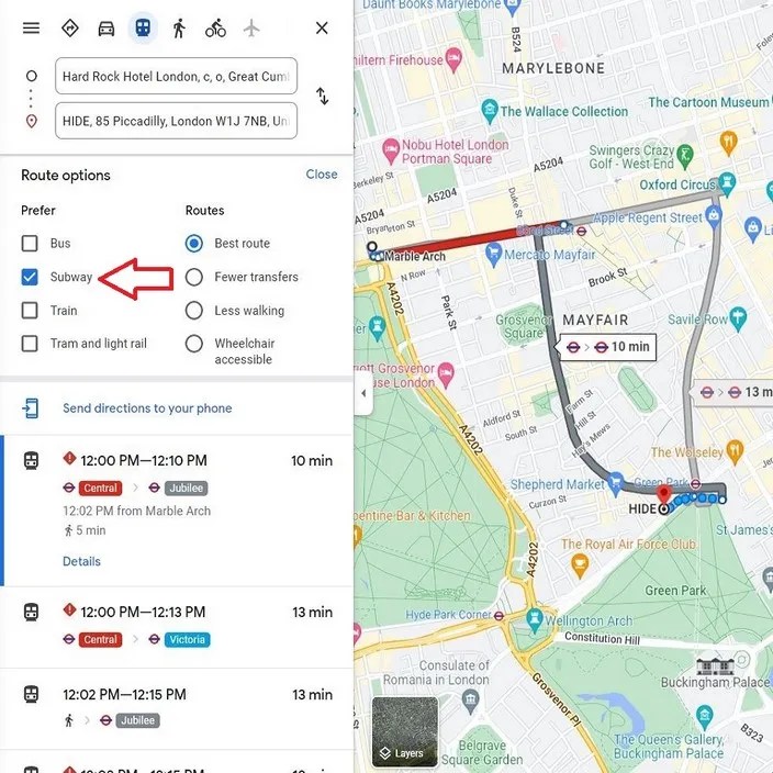
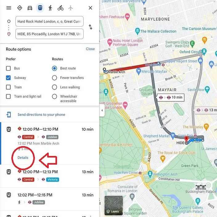
- Show the Details for the Subway Route - Slide 18Let’s click the link to view Details for that route that includes taking both the Central and the Jubilee lines (estimated to take about 10 minutes).
- Route Details for the Best Subway Route - Slide 19The selected route involves a short 2-minute walk from the Hard Rock Hotel to the Marble Arch station. We are directed to take the Central (Red) Line in the direction of Hainault via Newbury Park leaving from Platform 2 at the Marble Arch station. We get off at the first stop which is the Bond Street station and we immediately proceed to Platform 4 at that station to catch the next car on the Jubilee (Gray) Line in the direction of Richmond. Again, we exit the subway at the first stop which is Green Park station. We then exit the station and walk for about 2 minutes to our destination at the restaurant HIDE.

- Return to see other Modes of Transportation Options - Slide 20Out of curiosity, let’s see what the time would be taking a taxi or walking. Click the back icon at the top of the page to return to the previous window.

- Taxi or Ride Share Options - Slide 20Click on the car icon to see how long this trip would take by taxi or using a ride-share service. It indicates it could take up to 8 minutes. And that doesn’t include the time required to flag down the taxi or the waiting time for the ride-share driver. So you can anticipate that this option would take between 10 to 20 minutes.

- The Walking Option - Slide 21We can see by clicking the walking icon at the top of the page that Google Maps indicates that walking would take about 22 minutes.
